Alimeter issues

Hi,

I have Fenix 5x+ ver. 4.65 Rel (4d836d8); GPS 2.24. During Activities no 1 and 2 I had 4.20 firmware.

I found few things I would like to share here and get information if it is normal situation or maybe I should change some settings in my watch.

Maybe somebody had this kind of problem and got the solution.


Autocalibration of Altimeter I set ON (Continuous). Also I set up Autocalibration when there is no Activity.


My questions are:

1. what kind of algorithm is used to make autocalibration? According to DEM or GPS?
2. why there is no option to choose autocalibration method?
2. how often is it made?
3. how can I set up in Garmin Connect that I want to see alitude but GPS Altitude?

what I noticed is:

1.
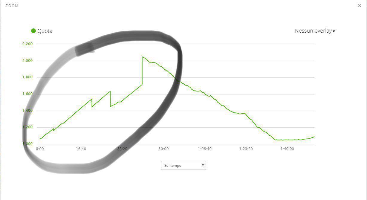
Below there is activity (that time the firmware was 4.20):

https://connect.garmin.com/modern/activity/2955312861

this Lake. Lago di Misurina is more then 1700 m. According to data from the watch it is 1250m. I had autocalibration ON Continous mode but there was no option auto calibration according to GPS or DEM algorithm. when I saw there is a problem with altitude I made it in manual mode after few minutes (there is a peak on the graph).

question is why I had this situation?

2.
similar situation is here (also that time firmware 4.20) when I was climbing on Cima Grande:

https://connect.garmin.com/modern/activity/2948329975

https://connect.garmin.com/modern/activity/2947760010

Cima Grande is about 3000m peak. on my watch there was no value which would be close to this number.

In my opinion the problem is that autocalibration is made according to cartographic data and not GPS data. I agree that cartographic data (DEM algorithm) is good solution but in case of this tower - peak it totaly failed. If there would be possibility to use auto calibration method in GPS algorithm/mode I think there would be no this kind of situation.


3.

I made also tests with firmware 4.65. (GPS 2.20). I think GARMIN change something. When I turn on activity in the city (auto calibration is ON Continous) the altitude was changed (calibrated) according to DEM calibration (GPS was different)

But autocalibration is made still with DEM method. I also made one more test:

https://connect.garmin.com/modern/activity/3034049645

I was on the plane. I wanted to check how it works with auto calibration. I wanted to be sure which algorithm is used to calibrate altimeter.

I am almost sure that the watch is trying to use DEM method to calibrate the altitude. not GPS. The user (I do not know why) is not able if he prefer to use DEM nor GPS algorithm (in auto mode. in manual mode you can choose it).. And that's why information about altitude which I have in Activity is false. Altitude according to GPS was true. but I can't see it in my Garmin Connect because only information about Altitude (which was wrong) is saved. if there would be AutoClaibration option according to DEM or GPS it would solve the problem (in this situation I could choose GPS auto calibration option).

Of course I know that the reason is stable preasure in the aircraft cabin but it shows one important thing: if you are at some point which is as tower, highest point (Wall) you won't get true information about altimeter in this mode. the watch will change it using DEM method.

if you climb (not go but climb with rope, like I did in activity on point no 2) to the peak which is kind of tower (and that tower is arround the flat place) then there will be a problem with correct information on the watch (Altimeter) if I have AutoCalibration ON. and at this moment there is no good solution. If I set it OFF. I can have problem with air preasure.

- autocalibration is ON Contionous. advantages: I don't have to make manual calibration, I do not worry about weather condition and changing air preasure arround me. disadvantage: DEM algorithm is wrong in that kind of places like towers. cartographic data which are used are not so detailed in case of peak with tower type. example: point no 2 and Cima Grande.

- autocalibration is OFF - bad solution. I have to think about it all the time, there could be a problem with changing air preasure, here I can choose if I use DEM or GPS calibration (and this option should be in autocalibration settings)

Solution for this problem in my opinion:

possibility of setting which method should be choose when I use auto calibration method.

why?

well, if I can use autocalibration with GPS not DEM during this climbing I have: no problem with changing air preasure during whole day, I have no mistake caused by DEM (cartographic) method. Probably, I would be able to get +/- 10m accuracy of my alittude. here I got +/- 150m or more...

if I use Forrerunner (no barometer) I could get better information about my position and altitude.

also, in the plane if I have autocalibration option according to GPS not DEM also I could have correct values of altitude.

4.

by the way, whay there is wrong information about speed (point no 3)? it was a plane. on the watch I got more then 800 km per hour. Also, when you see basic data about activity you see:

655 km distance, 58 minutes, 201 km/h average speed. ... it is quite easy to calculate that average speed is not 200km/h but about 700km/h. Speed graph also shows that the speed was not higher then 200km/h but on the watch I saw more then 800km/h. why there is difference?


5.

if I make calibration of Alitmeter in manual mode and I am on 200m and put there 2300m, should the watch change this value (I have settings AutoCalibration ON (Continous)) when I start Activity?


6. Auto Calibration during non activity time. Watch is not moving. (during night)

I have question here.

Auto Calibration I think is working properly. I leave on 200m and even I have other value at the end of the day (i.e. 190) when I woke up I have 200m. Usually.... but last night the weather changed during night and I woke up with 220m. I have watch mode AUTO (barometer/altimeter). but why the watch thought the altimeter is changing if there was no movement? (the watch was on the table near by bed, zero movement). it should check if any sensor see movement or not, isn't?

how often autocalibration is made with no activity?


Waiting for your advices...


  • Former Member
    0 Former Member over 6 years ago
    Could you please show the activity here? or write which via ferrate it was? I am wondering how it was going in the mountain, tower/wall character?


    That was the ascent to "Kleiner Bettelwurf". On the way further to "Großer Bettelwurf" it didn't occur that way again although that was a kind of "wall" much more than the way to "Kleiner Bettelwurf". But auto calibration wasn't exact as well.

    Here is the link to the activity

    https://connect.garmin.com/modern/activity/2892787992?share_unique_id=3
  • what was the accuracy during autocalibration?

    I was talking about this issue with other user of GARMIN. His suggestion was to disable DEM BaseMap. We can try to make test. Maybe then there is autocalibration only using GPS. I let you know after tests. if you do your tests let me know.

    yesterday, I had +/- 10-15 meters of difference between GPS Altitude and Altitude from Barometer (during AutoCalibration), during Activity on path in mountains. but it was short activity only 1 hour, and difference in altitude was about 200-300 m only.

    at this moment I have 5.10 firmware on the device.
  • I made another tests... it was also in the aircraft. I turn off DEM Base Map on the watch. I had AutoCalibration ON, but it still didn't use GPS Altitude to correct value on Altimeter on the watch. I also did test with all maps turned off. problem the same. During Activity (Follow Me, Tactical) I have correct Altitude from GPS but Altimeter was crazy. I think even all maps are turned off it is trying to follow DEM algorithm when autocalibration is on and it is mistake in my opinion.. the problem would be solved if Garmin allow to user to setup mode of AutoCalibration: DEM or GPS. Now, it is simply not working during climbing or in the aircraft with stable pressure.

    see my photos and movies from this test:

    https://drive.google.com/open?id=1Mj...Y--F8lGPeDOGXK

    description of files:

    01 & 04 - we are on the ground just before take off. Altitude is similar to Altitude GPS.

    other photos and movies are when we are in the air. (there is clock or stopwatch on the facewatch you can see the time).

    Quite strange thing is on the movie no 09.

    at the beginig of Activity I did not turn on START. The watch shows the first screen with data. As you can see Altimeter is making quite fast calculations (like it was trying to make some corrections (?AutoCalibration (it is ON)? but I didn't push START button). and after I push START this data filed is not so cracy is making slowly value up. but it never went to correct Altitude (Altitude GPS)).

    All maps in settings were turn off.

    It looks like there is no rule of working this AutoCalibration. Like watch do not know what to do and it doesn't matter if I turn on or turn off maps (my first test month ago was also in the aircraft with all maps ON).

    I am pretty sure something is wrong with this AutoCalibraiton especially in vertical activity.

    It could be good if somebody from Garmin could tell us what happends and why.

    Today I am sending links to this post to Garmin Support. because till now nobody take care this I think.

    my firmware is 5.10, GPS: 2.30
  • I have also tried turning DEM map off in an activity, and the watch still did not calibrate from GPS.

    In my case, I was at terrain level, so I actually got the correct calibration from DEM. But I agree with you that this approach is not usable in general, because there will be too many situations where one is above terrain level when doing an autocalibration.
  • yes, the problem is that they are not able to have in every situation correct information from contour line in DEM map. the problem is Garmin force user to use it and should give us choice which Calibration method we want to use. it should be enough.
  • Same problem for me with last 5.10 sw. The graph is not linear.


    Ouch. This is the kind of autocalibration that I have always feared that Garmin would start using: Frequent checks of altitude error, and a sudden recalibration if the error gets too large. That is definitely not the way to do it.
  • The questions is if it was autocalibration or he did it on manual to correct the value od altitude. @antoniovertical could you continous it? For sure it is not working on the way I said becuase at this moment there is no this option. If there was autocalibration on the it must be by DEM, I think.

    Another thing is what id better. If you have this peak but after that real data or od you have nie graph with totally wrong information.

    Also if you chose to do it as manual calibration you also gry the peak od there is a problem with data and you want to calibration it.

    @antoniovertical let us know how you get this graph.
  • Former Member
    0 Former Member over 6 years ago
    I recently did another bike and hike tour in the alps with Firmware Version 5.00. Altimeter Settings Auto calibration during activity continous. It was quite a Long tour with all together about 1.900m in altitude up and down. This time i was for most of the tour quite happy with the Altimeter....it was quite accurate and on spots with known altitude (especially summits) only a couple of meters off....so much much better than my last experiences with Auto calibration with older firmwares. BUT: On the last descent of the hiking part the Altimeter was wrong for about 80 meters in altidude when I reached my bike at the mountain hut. I started at the last summit at 2.240m and the mountain hut where my bike was was at 1521m. Altimeter showed 1605m. So on this pretty short distance the Altimeter was quite wrong. As I mentioned during ascents Altimeter was quite good. So I manually calibrated the correct altitude: GPS-altitude showed me 1524 meters but what is really interesting DEM showed me 1518 meters, so also quite accurate. So I think you can't say Auto calibration is wrong due to wrong DEM as Krzystof supposed. So maybe there is another bug with Auto calibration of the Altimeter. As i mentioned before Auto calibration with my suunto ambit3 Peak always worked very very well.

    Here is the link to this activity: https://connect.garmin.com/modern/activity/3094411925

    I discovered another phenomenon with the Altimeter when doing a running activity from home: I did 3 running activitys so far from home. The altitude there is about 515m. So I always calibrated the Altimeter to this altidude when it was a bit off. But the thing is now when I start the running activity the Altimeter seems to suddenly jump to about 1400 meters in altitude (!) in all 3 runs I did from home so far.....I have no idea for the reasons.....when I do cycling activities from home this issue never occurred.

    Here is a link to one of the 3 runs: https://connect.garmin.com/modern/activity/3126192269
  • This is so disappointing .. Hr doesn't work right , barometer , temperature ,altimeter, GPS...

    So what works right on this fenix watch ?The time and date for 800$?