Accuracy of Montana 700 Topo graphics

I have been trying to use the Topgraphy feature in the Montana 700 here in Abu Dhabi in my jeep. But I am finding the elevation information incorrect.

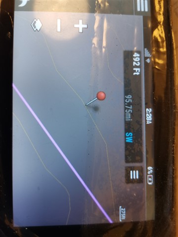
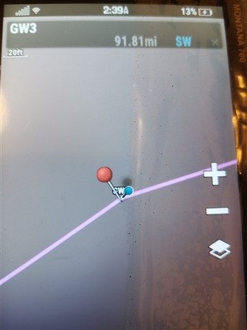
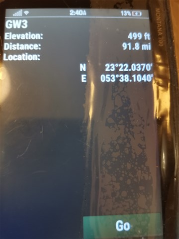
The Garmin shows me Elevation lines at 429 in this area of dunes and sand. When I put a pin on this line and press for more detailed information, it shows me anything but 429 ft. I have tested the feature in other nearby deserts and with a 625 ft elevation line. I met with the same problem.

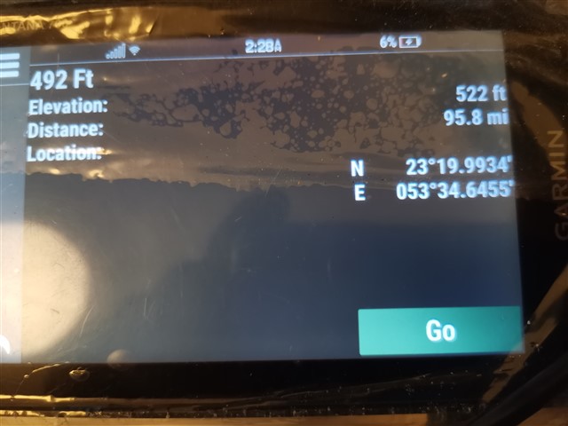
I also have the documented measure of the elevation of a waypoint....it is 382 ft. Yet the Garmin 700 Montana shows this point to be at 499ft This is a 100ft or good a 10 storey building type of  difference in the layout of the land. This can be tragic in a car.

Can anyone please add to this? Are you encountering the same level of inaccuracy with the Garmin 700 Montana topo graphics.

Sikander

  • You need to learn how the GPSr functions before declaring it inadequate.

    When you select a map location to check elevation, that information is usually pulled from map data loaded to the device. Perhaps you need a more detailed map for the area you are interested in.

  • I am not declaring GPS inadequate, I am questioning the accuracy of Garmin Montana 700.

    I have the latest Middle East Topo map. But if you read my initial problem it said that when I click (by putting the pin) on the 492ft contour line, the detailed values don't show 492ft. It shows a different value.

    Why is that? Perhaps you are suggesting that the contour value comes from the map and the detailed value from the GPS  read by the Garmin.

    I can assure you that the Garmin overlander shows very different contour lines. 

    Yes and the other question was about the specific location. Which you said is 415ft from Nasa data.

    So why does Garmin reading show 499ft. Why not 445ft or 381ft as another traveler whose route I am following has recorded at the site using an older Garmin

    I use the Garmin for navigable course  planning purposes, and not for the accuracy of the elevation when I have arrived there.

  • I can assure you that the Garmin overlander shows very different contour lines. 

    I suspect your Overlander has different 'Elevation Map' data loaded than the Montana.

    I am not declaring GPS inadequate, I am questioning the accuracy of Garmin Montana 700.

    The Montana can only provide you with information from the data loaded to it.

    Again, I suggest finding a map with more detailed elevation data. That may be more difficult than it sounds, as many countries do not allow map makers (like Garmin) to provide very detailed information for reasons of national security, etc. I am not familiar with UAE policies, and can not offer further advise or information on that matter. You will have to research this yourself.

  • I agree with a_c's comment.  The elevation readings that are mentioned as in sunstantial error are not from the GPSr.  They are from the contour lines on the topo map and your visual interpolation of the pin marker's location between them.  The GPSr derived elevation error will never approach the height of a 100 story building.

    When I drive my Jeep in the mountains I accept the elevations calculated by the GPSr from the satellite's transmitted data.

  • Thank you both I much appreciate your learned and experienced insights.

    As related to the second point. If I am reading a coordinate's elevation from a 100 miles away, what level of accuracy should I be able to achieve?

    I am referring here to N23 22.037, E53 38.104, which the Nasa data is showing as 415ft and the calibrated Montana 700 is showing as 499 ft. This is a GPS reading from 100 miles away. As opposed to a contour reading on the Montana which may have a mismatch with GPS.

  • There is the inherent issue that vertical measurements are considerably less accurate than horizontal measurements with a GPSr. There’s also the level of accuracy of topographic maps, when they were created, what datum they use and if a datum conversion was accurate. Also, one cannot simply zoom all the way in and interpolate between contours whether the GPSr or a map user, and expect it to be accurate because the level of accuracy of the map has been exceeded. Bottom line, I wouldn’t be surprised if the elevation of a sand dune varies by fifty feet or more among sources. Apologies in advance if this isn’t relevant to the topic.

    I got this from Garmin’s site but there is plenty on the Internet that explains it:

    GPS heights are based on an ellipsoid (a mathematical representation of the earth's shape), while USGS map elevations are based on a vertical datum tied to the geoid (or what is commonly called mean sea level). Basically, these are two different systems, although they have a relationship that has been modeled.

    The main source of error has to do with the arrangement of the satellite configurations during fixed determinations. The earth blocks out satellites needed to get a good quality vertical measurement. Once the vertical datum is taken into account, the accuracy permitted by geometry considerations remains less than that of horizontal positions. It is not uncommon for satellite heights to be off from map elevations by +/- 400 ft. Use these values with caution when navigating.

  • If you want to determine accuracy and precision of your GPSR's elevation values, post back and I will describe my methods.

  • Three items to test: Barometer (Precision), Weather effects on barometrically derived elevation (Precision), and GPS elevation (Accuracy and Precision).

    Assumptions: The test results are unbiased, random, and normally distributed.

    Definition of Normal Distribution: en.wikipedia.org/.../Normal_distribution

    For definitions of Accuracy and Precision: https://en.wikipedia.org/wiki/Accuracy_and_precision

    Trip Computer Page Adjustment: Change Data Fields to display Elevation (barometrically derived), GPS (derived) Elevation, Barometer and Ambient Pressure.

    Barometer (Precision): Standing in one location, record an Elevation value every 5 seconds for 20 values. Use a spreadsheet app such as MS Excel or LibreOffice to calculate the standard deviation of the collection. Assuming none or extremely small weather variations during that 1 min, 35 sec test, the standard deviation defines the precision of barometric sensor.

    Weather effects on barometric elevations (Precision): Record an elevation, in the same location, once per day, for twenty days. Do not re-calibrate the elevation during the teat. Calculate the average elevation and standard deviation for that collection.

    GPS elevation (Accuracy and Precision): Record GPS elevations, in the same location, three times per day, at least 4 hours apart, for 7 days. Calculate the average elevation and standard deviation for that collection.

    Observations: Assuming unbiased and normally distributed GPS elevations, the accuracy of the average will be very high. Comparing the standard deviations of the three, the precision of the one per day barometric will be several times greater than that of the GPS, and the GPS will be several times greater than that of the barometric.

    Conclusions: The much greater standard deviation of the 20 day group is due to weather variations. Determining the height of small hill, of 50 feet or so that could be walked down in several minutes, I would use barometric elevation at bottom subtracted from that at the top. Traveling up and down through a mountain range for a period of several days without a bona fide elevation reference, I would use GPS elevations. Over a several day period, typical weather variations will negatively affect the barometric elevation accuracy.