This discussion has been locked.
You can no longer post new replies to this discussion. If you have a question you can start a new discussion

Garmin Connect Courses elevation gain grossly overestimated.

Former Member
Former Member

When creating a course on Garmin Connect the elevation gain is grossly overestimated. I can download the GPX and upload to other programs (e.g. strava) and the courses match reality. It is very large over estimate of 30-40% and obviously wrong by inspecting the plot. Anyone else seen this and is there a fix?
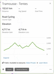
Note same file in Strava is approx 3200m elevation gain.

  • If the elevation values from the provider of the topographic data do not correspond to the actual elevation of the road, then these elevation values are inaccurate and should be corrected. Ridewithgps.com and others have obviously understood this.

    All what Ridewithgps.com does, is filtering the bumps. In your specific situation (where the road does not truly copy the terrain) it may give better results, but in many situations where the road or the trail copies the terrain more accurately, hence the topographic data matches the reality better, the filtering of the bumps would result in a gross underestimation of the elevation gain/loss. So there is no ideal solution.

    Garmin apparently opted for showing the raw data without filtering. Neither of the solution is good or bad. They each are better or worse in specific situations. Fortunately, you have the choice, and can prepare the course with the tool better matching your needs.

  • Yes, and I will choose other navigation tools to create my routes, as based on my experience, the data presented by Garmin often do not correspond to what I see when cycling up mountain roads. The number of threads and comments existing on this topic indicates that a number of people seem to feel the same way.

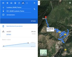
  • Btw, I just drew the course on Google Maps, for even another separate comparison. Lo and behold, they report 363 m of elevation gain and 0 m of elevation loss. This reported elevation gain is right around that 340-360 m range reported by two bike computers with barometers and by other navigational tools, and, importantly, the numbers (and the elevation profile graph) correspond to what you see if you are on site, i.e. a steady climb with zero elevation loss. Again, it's an ocean away from the 647 m elevation gain and 275 m elevation loss reported by Garmin for the same segment. If using the 350 m mark as a reference, for this road, Garmin overestimates the elevation gain by 85%. In terms of accuracy and validity of the Garmin Connect elevation numbers, there is no other word for this than horrendous.

  • What I noticed: if I send the course through the Webpage or Connect to the device, the elevation is way off. If I copy the very same file to the device by hand, it seems to be correct (or at least what I would expect). So there seems to be a bug in the transfer or the way the device handles files from Connect. Can anyone reproduce that?

  • Hi Mario. What you are describing is exactly the problem discussed in this thread. Whether you 1) are creating a new course in Garmin Connect, 2) you are manually importing a course file from elsewhere into Garmin Connect, or 3) are sending a course file from elsewhere to your device, but via Garmin Connect, the result is the same, i.e. the elevation gain/loss numbers reported by Garmin Connect will prevail, and override any elevation numbers from a separate source. The only way to get a course file to your Garmin device without Garmin Connect's elevation numbers, is to copy the file to your device in Windows Explorer.

  • Hi - exactly. I only wondered because someone from Garmin was describing the way of calculating the elevation. From my point of view this bug has nothing to do with the way of calculating, but with the way it is transferred to the device. I suspect that there might be a problem with meters / feet (something like a wrong conversion) -> the 30% at least give kind of a hint to such an issue.

  • someone from Garmin was describing the way of calculating the elevation

    Nobody from Garmin participated in this thread

    From my point of view this bug has nothing to do with the way of calculating, but with the way it is transferred to the device.

    No, it really comes from the unfiltered Elevation Gain calculation. When you import a file from an external tool, and send it to the device through Garmin Connect, it will recalculate the elevation gain consistently with their policy of unfiltered calculation (including all bumps). The only way you can bypass it, is uploading the course file directly to the device over the USB cable, bypassing so Garmin Connect.

  • hey, if anyone is still following this thread: i just tried 3-4 tracks imported directly and via komoot and for the first time ever, there seems no big difference in the elevation. so the problem might be fixed? can anyone else try some tracks also?

  • I can confirm that courses transferred through the Komoot IQ App on the Edge 830 device are fine (that is what I always do). If I export a course from Komoot, import it to Garmin Connect (there the values are still correct) and send it to the device from Gramin Connect, the issue is still the same: about tripple the vertical meters. 

  • ok, i have the two accounts connected and the tracks were on my watch after a normal mobile connect sync. the comparison i synced via the connect iq app (my usual gold standard). for the first time though, the elevation profiles were basically the same...