garmin 18x usb receiver

Former Member
Former Member
Can anyone tell me a bit about using the garmin 18x?

Since the output is not in standard format, does that mean it will only work with garmin specific software.
Are there software adaptors to turn the output into standard gps output?

What software is used with the 18x?

Is there a reason to buy the 18x over some of the cheaper units like:
GlobalSat BU 353 S4 usb GPS Sirf 4

I read one report saying the Star IV chip does have a problem with taking WAAS/EGNOS input.
That user recommended the 18x for that reason. Are there other similar probs with the cheaper units that are not shared by the gamin 18x?

Any info would be helpful.
  • Former Member
    0 Former Member over 12 years ago
    It comes down more to how well the math in the units deals with the multipath.

    Math certainly helps but consumer GPS'es only use one GPS frequency as the other (military) one is encrypted. In short you can only get so much accuracy.

    WAAS helps as does averaging (the longer the better) but civilian units, unlike in Hollywood movies, can't get you to the nearest inch/centimeter.
  • Former Member
    0 Former Member over 12 years ago
    No. The Oregon should perform better than the 18x.


    Why is that?

    If you just walk up and take a waypoint, in heavy tree cover, then 10-20 meters is expected. You need to stop, hold the antenna above your body and let it settle, then take a waypoint and start the averaging function until it reaches 100%. If you want to check the waypoint, walk away 50 meters and then navigate to it with the GPS. If it is off, you have not gotten a good reading and you should try again.


    Thanks for that tip.. I never paid any attention to the waypoint averager thing... I'm eager to try that now...
  • Former Member
    0 Former Member over 12 years ago
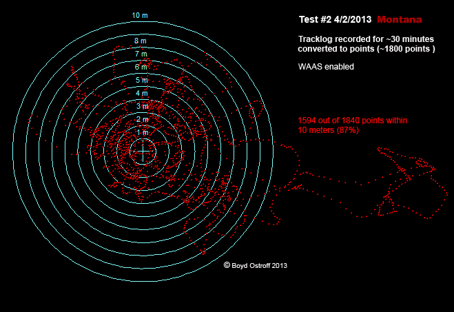
    Waypoint averaging can make a big difference. The longer you let it sit, the more accurate it will be. Here's a test I did with my Montana as part of the GLO review I mentioned before. The Montana uses the same chipset as your Oregon and should perform similarly. I let the unit sit for 30 minutes and record one point per second. The result was about 3600 points which are plotted here, with the center of the target being the actual location.

    This should make it easy to visualize; if you just record an individual waypoint, it's the equivalent of one dot on this image. If you happened to record the waypoint at the "wrong time", it could be one of those points at the righthand edge of the image, 20 meters away from the actual location. So how much of a gambler are you? ;)

    However if you used waypoint averaging for 30 minutes, you would end up very close to ground zero. In other words, even though the points are scattered all over, like a shotgun blast, the center of the "cloud" is very close to the center of the target.


    And for reference, here is the same test performed with a GPSMap 60csx which uses the SiRFstar III chipset. Both units were sitting side by side during the test. It shows a tighter cluster of points but also some significant "wandering". And keep in mind that these tests were done in an open area with no tree cover.

    -Boyd

  • @OSTROFF01

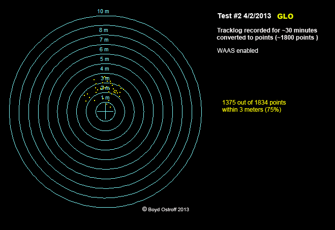
    I looked at your static GLO plot. I’m pretty sure you’re seeing the effect of a Static Navigation feature. Without knowing how the feature works you really can’t draw in meaningful conclusions.

    @HPUT3

    If I had to relocate a specific tree in a forest I would mark the tree the first time.
  • Former Member
    0 Former Member over 12 years ago
    I looked at your static GLO plot. I’m pretty sure you’re seeing the effect of a Static Navigation feature.


    Even if it is the effect of Static Navigation, so what? The software is filtering out data that it feels is erroneous, and it's doing a great job at it. Look how closely spaced these points are - this image actually has 1800 points just like the others, but many are stacked right on top of each other.

    If you aren't moving - static - then why would you want to see your position drift wildly around like the Cartesio and SirFStar chips do? This tightly clustered group of points is just what I want for recording waypoints.


    But really my point in posting the other two images were to show what kind of error the OP might expect from his Oregon (same chips as my Montana) as well as the USB SirfStar III device he was considering.


    -Boyd
  • If you aren't moving - static - then why would you want to see your position drift wildly ...


    It depends on your objective. Let’s say I am doing stationary measurements for the purpose obtaining a position (Lat/Lon) that is as close to the true value, with an acceptable level of uncertainty, as possible.

    While I would prefer a means that is both precise (small spread of data) and accurate (result close to the true value), I would gladly sacrifice precision to obtain accuracy – at least up to a point. In practical terms, I would have to collect more data.

    I assume that the purpose of a Static Navigation feature is to prevent unwanted route re-calculations. If this is so, then the feature probably doesn’t care about positional accuracy (true position), it is likely concerned with minimizing drift over a period of time – say on the order of a stop light changing from red to green or the passage of a freight train in a town.

    In other words, regardless of the accuracy of the GPS position when the device decides it is stationary (off by 0.5m or 5m from true) the feature will likely want to log a position at or very near the original false value.

    Of course, my assumptions may be wrong. The real point is that a single experiment doesn’t have much meaning. Yes, the GLO gave a tight cluster of points, but the true position is outside the cluster. Very little significance can be placed on either observation based on a single experiment.
  • Former Member
    0 Former Member over 12 years ago
    Actually I did the same test twice because I forgot to enable WAAS on the Montana and 60csx. I may have messed up and recorded that "tail" by accident walking to the test point; was doing this with Globalmapper on a tablet in the bright sun which is pretty awkward. ;) Or the position may have just "wandered" like it did on the other units. But even taking those points into account (total of only 41), 87% out of 1862 samples were within 3 meters - actually statistically better than the other test.


    I am perfectly happy with 3 meter accuracy from a device that cost me $90 and don't care if it filters out values that are obviously wrong. I will do some further testing eventually at my property markers since I've tested them repeatedly with an Oregon and 60csx in the past.

    But I've done enough testing to form a very favorable first impression of the GLO for my own needs. I'm not selling anything, just sharing what I've learned. But I should also point out that I got the GLO to use as a receiver for a tablet in my car running Mobile PC with custom maps that I've made. The static performance was just a "bonus" for me, and not something I will ever make much use of.

    If you need to collect accurate scientific data, then you should consider "you get what you pay for" and not expect too much from such an inexpensive consumer product. This is probably what you should be looking at, and you are going to spend a lot more than $90. :p http://www.trimble.com/mgis_highaccuracygis.shtml

    -Boyd
  • @OSTROFF01

    We don’t want to steal the OP’s thread topic. My original comment towards you was just a possible explanation for the GLO plot in a link you provided.

    The second post was an attempt to explain why one might accept a larger scatter of data points. I attempted to do this in terms of a GPS example, but that may have been a mistake.

    Neither of my posts are a comment on the GLO device. I’m glad you’re happy with it and I see no reason why you shouldn’t be.

    If you like running these sorts of tests, go for it, but don’t do it on my account.
  • Apologies to OP for being off-topic...

    Do we have a forum for the GLO? If not, is there any way to ask Garmin to create one?

    Failing that, where else on here would be a good place to discuss GLO matters?

    thanks!
  • Former Member
    0 Former Member over 12 years ago
    Garmin only has forums for their sports GPS devices. Why?.... I don't know. I really doubt there's enough interest to warrant a special forum for the GLO itself. Here are a couple threads on other sites however:

    http://www.laptopgpsworld.com/4860-garmin-glo-bluetooth-glonass-receiver
    http://forums.gpsreview.net/viewtopic.php?t=27533

    -Boyd