Hello everyone. Can you tell me why the grid lines on the maps on my screen in Basecamp now appear slanting? - my maps seem to have gone skew-wiff! . Thanks.
Assuming your map orientation is set to North and the map is correctly georeferenced, it is probably because you are not using the OSGB datum. Go to Edit > Settings > Measurement and change Position: Grid to British National Grid.
Thank you Eyelet - It seems to be set on British National Grid - and I have clicked "align up North" - and still have same problem. Heading is "automatic magnetic variation" and grid is "British National Grid"
Which version of the OS maps are you using - Garmin's Birdseye Select?
Don't the grid lines look skewed because they are displaying the curvature of the earth on a flat map? My Garmin Birdseye Select OS maps are the same. I think these Garmin maps were scanned from paper maps so they are bitmap images with no software manipulation to align them on screen. If you look at a different area of the country the grid lines will be skewed differently.
I also use other mapping software (Memory Map) but this uses vector mapping rather than bitmap images and the gridlines are always vertical and horizontal where ever you look across the country.
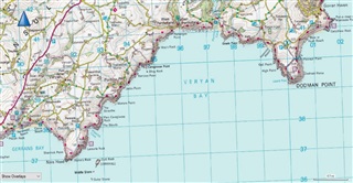
I think we have now established that your BaseCamp set up okay for OS mapping and with North Up. I live in North Yorkshire and am used to plotting tracks in the north of England and Scotland, where the grid is not slanted much. If I scroll my Garmin-supplied OS 1-50k raster map to the same area as in your picture, the grid is similarly slanted to yours. If you scroll further east to the Isle of Wight for example the grid is level and further east to Dover, the grid slants in the opposite direction, so I agree with BiscuitDunker's explanation. This is a helpful read: https://www.bnhs.co.uk/2019/technology/grabagridref/OSGB.pdf
As far as I know all rendering of OS mapping are from raster map tiles and none are vector maps. I wonder if Memory map is simply using a different projection to get the grid oriented vertically and horizontally across the UK?
BiscuitDunker is correct that the process of converting a curved surface to a flat surface results in distortion. If I found the correct information on the grid system in your country, the only grid line that runs true north will be found at W 2° using the Ord Sys Grt Britain datum. It that line looks fine, then all is well.. As also pointed out, a map that is not properly geo referenced will also cause the grid to be misaligned.
Eyelet99 - Sorry, I stand corrected. The Memory Map mapping is not vector drawn. Don't know why I'd made that assumption. But it does display with all the grid lines aligned North-South and East -West where ever in the country you look at the map. Just like if you trimmed and joined up an area of the paper maps - everything aligns.
In Basecamp - if I use the compass tool (the blue arrow top left of map) as suggested by Sussamb or click on the "Align North Up" in the View menu, does that set the map to True North or does it depend on what you set in the Edit, Options menu? Other than turning the compass tool, changing any of those option does not seem to make any difference to the Birdseye Select OS map. I can't see how selecting Grid North could work as the grid lines are distorted anyway.
The blue arrow/compass tools alters the orientation of the map. The "Align North Up" in the View menu returns the map orientation to true north. The Heading selections under Options > Measurement relate to headings not map orientation.
I'll try to give a UK example. Set your datum Ord Sys Grt Britain, the Grid to British National Grid and Heading to True. Go to somewhere around Plymouth and use the Track tool to create a track that heads true north. Just click once anywhere in the area, move the line north any distance and don't click a 2nd point until you see the heading read 0.0° true in the bottom bar of BaseCamp.
Now click on the Hand tool to stop adding track points. Open the Track Properties and you will see a Leg Course of 0.0° true. Close the Properties and switch the Heading to Automatic Magnetic Variation.
Open the Track Properties again and you will see the Leg Course will have changed. This is the compass heading relative to Magnetic North that you would need to follow to reach point 2. The correction comes from a table in BaseCamp.
The grid setting will tell the direction relative to Grid North (not Magnetic North) that you would need to follow.
Magnetic north changes over time and in some areas magnetic anomalies occur making table values inaccurate. The User Magnetic Variation allows you to enter a correction value of your own to get a compass heading relative to Magnetic North.
The Cardinal setting will just give a rough direction like "N", "SE" etc.
These settings will also affect what you see in the bottom bar of BaseCamp when using the Track/Route/Measure tools. I hope this isn't too confusing.