This discussion has been locked.
You can no longer post new replies to this discussion. If you have a question you can start a new discussion

Possible solution for Some VA3 Altimeter Issues?

Former Member
Former Member
As many have reported, the altimeter on the VA3 is insanely off. It thinks I'm running downhill nonstop when I'm running up more hills than down.

Now, I notice that when the autosharing with runkeeper is active, runkeeper has the altitude right. See this example of a recent run (and no, I am not fast, but let's ignore that for the moment).

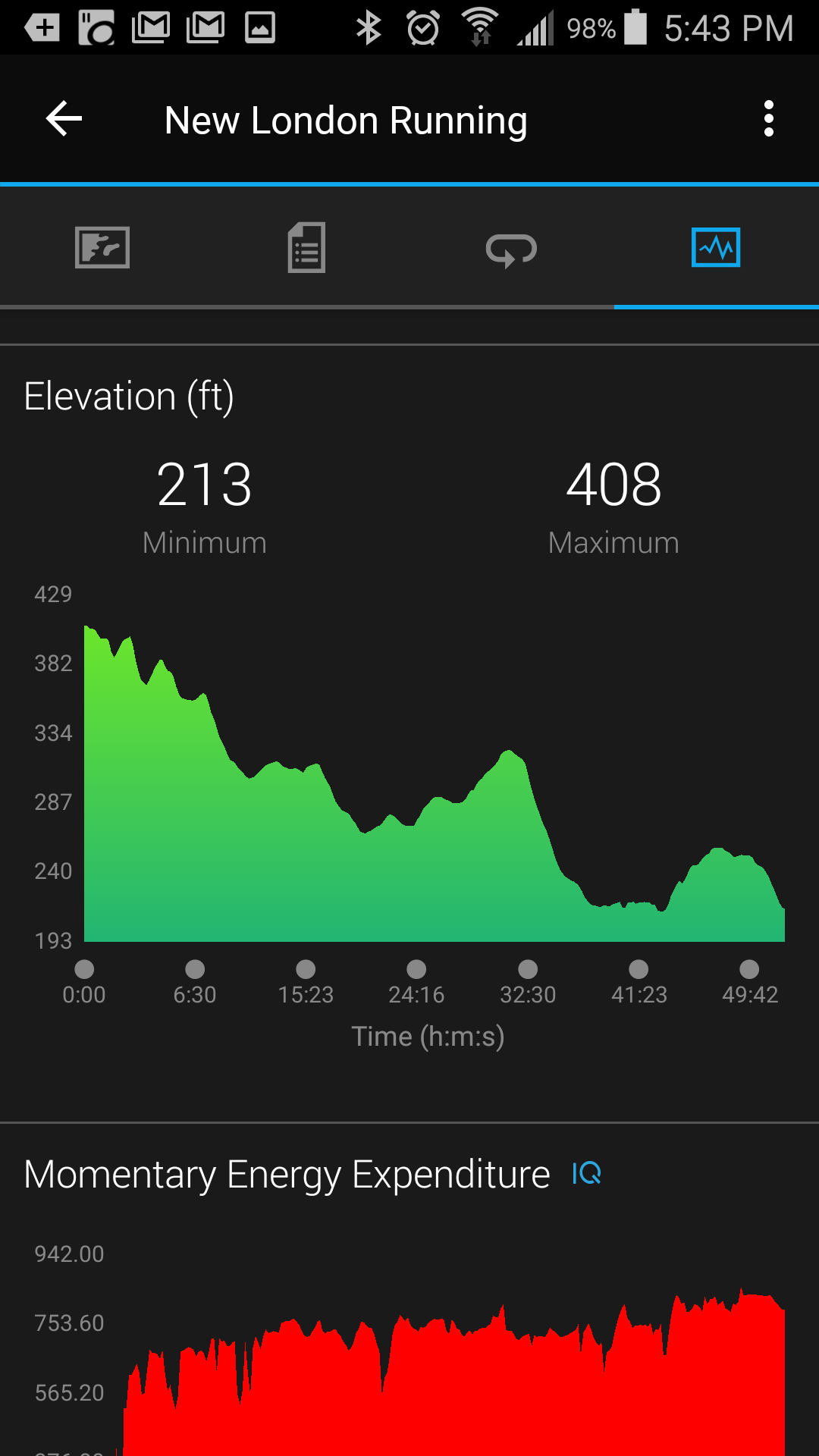
Here's a 5 mile run, doing 3 laps around a neighborhood. Runkeeper shows the repetition quite well. Let's see how garmin does:


And here is another one, this one just 2 laps.


What I think is happening is that for some obtuse reason, garmin, king of the gps, is trusting it's own altimeter over gps when the gps is active. Yet, many people when tracking, will be using their gps to record.

A simple fix seems to be to trust the gps more than the altimeter, and if the gps altitude is more than say 20% off, reset the altimeter to the gps. So, like this:

If (gps_active && gps_sats >3) { // gps altitude should be correct
altitude = gps_sat_alt
} else if (gps_active && (gps_last_altitude < 2 min ago) ) { //Get rid of outdated data if gps out for an extended period.
altitude = gps_last_altitude + altitude sensor differential //Really, this should just reset the altitude to the last known good and go from there, but I don't know how they coded it.
} else {
altitude = altitude_sensor
}

I mean, this clearly isn't perfect, but it at least means that TRACKED activities should be right, and that should make MOST users happy. I mean, my stair count is way off, but that isn't going to make or break me. Having accurate altimeter while running, now THAT would be when I care.

???????I'd love to hear any thoughts.
ciq.forums.garmin.com/.../1402740.png
  • I think it’s quite possible that running keeper is using map data for its elevation, and ignoring the elevation data passed through the Garmin data. I have a few tracks that cross bridges over the river into D.C. Runkeeper data shows a drop to zero elevation and a perfectly flat line over the bridges. Garmin track data does not.

    If you go into Garmin Connect in a web browser you can enable elevation correction on a per activity basis, and the results will probably look similar to runkeeper.

    Personally, for the purpose of tracking activities using GPS, i think the map data (i.e. Digtal Terrain and Elevation Data, aka DTED) will always be more accurate, since I never leave the ground while running. I wish that was the default. Like you, I’m not as concerned about tracking stairs climbed over the course of a day, but it is still annoying that the VA3 doesn’t do that very well.
  • Former Member
    0 Former Member over 6 years ago
    In thinking about it, I think it is far less likely that it uses map data vs gps data. Map data is rather inaccurate. Most topographic maps, such as I used to pull in from google earth for drawings, are far less accurate than a gps seems to be, even with the gps being averaged. The tightness of the dips and valleys speaks to something more accurate, namely, using the more precise gps.
  • I’ve upload three screenshots, all are elevation data from the same activity.
    1. Garmin elevation as reported by VA3
    2. Elevation from same activity with “Elevation correction” enabled in Garmin Connect
    3. Elevation as reported in Runkeeper


    According to Garmin Connect: “Elevation Corrections are calculated with data from professional surveys instead of the data from your device. If your device has a barometric altimeter, Elevation Corrections are disabled by default.”

    I’m not 100% sure I’m correct, but the runkeeper elevation looks a lot like the Garmin version when elevation correction is turned on.ciq.forums.garmin.com/.../1402901.png
  • Former Member
    0 Former Member over 6 years ago
    It took me a while to figure out that in order to get meaningful elevation data I had to turn OFF the "elevation correction" feature. The statement that they use "professional surveys" is rubbish - they don't have access to any such data for my country (Iceland), it is considered proprietary information. What they are most likely using is the so-called GTOPO30 database which is notoriously inaccurate. Within the band 57°N to 57°S they probably use SRTM data - better but still not very good.
  • Former Member
    0 Former Member over 6 years ago
    To add to the previous - the Vivoactive doesn't have an altimeter as such (if it did they wouldn't be applying the "correction" according to the quote above) - but it receives elevation information from the GPS constellation. This information is less accurate than the horizontal component, I seem to recall the error is about double - call it plus/minus 10 metres. That's a LOT better than what their DEM produces, the mountain I use for my exercise is 780 metres high, the "corrected elevation" gives 550 metres! They also cheat me out of a few metres at the bottom end, I start at 15 metres AMSL but they claim it's 55 metres AMSL.

    Although you can correct the information by disabling their "correction" this only works for activities you have already completed, in designing courses they apparently use their DEM data - and even if you base your work on an actual GPS track they simply throw away the elevation component. Engineers ....
  • To add to the previous - the Vivoactive doesn't have an altimeter as such (if it did they wouldn't be applying the "correction" according to the quote above) - but it receives elevation information from the GPS constellation.


    That is not right. The VA3 has a barometric and temperature sensor, which both combined gives you elevation.
    This does not work right from the start, due to several factors:
    • It will be calibrated via GPS, which is not optimal. But Garmin removed the manual calibration option (Only Garmin knows why)
    • The temperature will shortly change if you go outside
    • The temperature will raise slow at the beginning of a run and heat up the device
    • The barometric sensor is located under the watch, which is not the very best position

    On my tests, the elevation is quite exact after about a quarter hour. Before it is reliable ~30 meters off.
  • Former Member
    0 Former Member over 6 years ago
    My issue is that I run several laps, and it ALWAYS shows me ending up way downhill from where I started... which to me, I would think that it may go up if anything based on the comments. Additionally, my "stairs" always show way more down than up. Something is not right, but I am really not sure how on earth it is calculating it. And less of an issue, I think it really affects the V02 max numbers, as it thinks my runs are easier, than a few months ago because of the discrepancy, when they are exactly the same, and I'm going a full minute faster, but it's the same v02 max? Something is off.
  • Former Member
    0 Former Member over 6 years ago
    dlasky Your VO2 Max is calculated using certain factors, but elevation gain/loss isn't one of them. It doesn't matter if your watch "thinks" you're running downhill, it's looking for improvements.


    WHAT IS VO2 MAX?


    VO2 max is the maximum volume of oxygen (in milliliters) you can consume per minute per kilogram of body weight at your maximum performance. In simple terms, VO2 max is an indication of aerobic fitness.It should increase as your level of fitness improves.
  • Former Member
    0 Former Member over 6 years ago
    Ahh, but I thought they would include calcs for difficulty into the performance. Since I think it is based on a ratio of heart rate/age/speed. So, for example, the algo could be:

    last 5 sec avg of (for example, since gps, etc is smoothed): heartrate *(ratio of elevation change, where it is a log curve of more increase means more of a reduction, no elevation change = 1, 1 m elevation change = .98 or something, could be a fun machine learning project with a large dataset)/speed*age ratio.

    Just my thinking in my head. Again, with a large dataset like they have themselves, that is something I would think would be an interesting algo to compile. Kind of like the maffetone style one for low HR training.

    And again, I really wish the altimeter defaulted to gps for accuracy when gps is used/
  • Former Member
    0 Former Member over 6 years ago
    Trust me, you don't want the GPS elevation. Think of when you are in the woods and can only "see" satellites directly overhead. This means the 3D fix will be terrible, and off by significant amounts first one way, then the other. It will only make matters worse. You would prefer to use the built-in barometer as much as possible, and only "tether" the chart line when you can be certain a 3D fix is excellent with map data to back it up.

    Honestly I think Garmin gave up on the VA3 with the port on the bottom, and is now moving on with the VA Music. Since the altimeter in the VA3 worked flawlessly when I first owned it, then a software update broke it, I am 95% certain it is a software issue. I cannot believe they have not fixed the software yet. I just visited out of curiosity to check.

    To the poster above with temperature, your device actually gets cooler on most workouts, not hotter. Counter-intuitive I know, but I have recorded many aggressive hikes where this is the case with the Fenix 5.

    Lastly those little environmental sensors (RH%, Temp, Pressure) stuffed in these watches may produce a lot of sensing noise, but they are surprisingly good at what they do. The only thing that can screw them up is poor surrounding circuitry, or poor code. Since the VA3 once worked, and stopped, I am pretty sure the hardware is sound.

    I am somewhat glad my VA3 sank to the bottom of a lake and I now have a Fenix 5, but it cost me dearly to get a reasonably working altimeter. What makes up for it is the impressive battery life.