This discussion has been locked.
You can no longer post new replies to this discussion. If you have a question you can start a new discussion

Gradient data field on Edge Explore

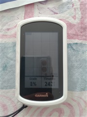
My wife's Edge Explore has a Grade % field in the elevation screen - see pic.  Mine does not and I cannot find it anywhere to be able to add to the elevation screen, or any other.  My old Edge Touring plus has a gradient data field and I found it really useful.  Does anyone know where it is on the Edge Explore ? 

  • I had a look at mine and I couldn't find the field either! Does your wife have a Connect IQ fields installed that is providing this?

  • Also see here:

    https://forums.garmin.com/sports-fitness/cycling/f/edge-explore/266744/grade-reading-is-completely-wrong

    I wonder if Garmin removed the field in latest firmware due to accuracy issues. What version of F/W does your wife have installed?

  • Confirmed. In the latest firmware version 5.40 Garmin removed the gradient data field. Here is the change log:

    Changes made from 5.30 to 5.40:

    • Fixed issue that track line color not match with the settings.
    • Fixed issue with ANT+ speed sensor firmware update.
    • Removed the Grade data field which is not supported.
    • Supported to backup sport profiles.
  • just checked - her Garmin is on 5.30 - mine is on 5.40.  Looks like I need to update her firmware.  Thanks everyone for your replies.  Wonder if Garmin are working to improve gradient calculation now they got rid of barometric measure?

  • Wonder if Garmin are working to improve gradient calculation now they got rid of barometric measure?

    Not sure I understand what you mean. The Edge Explore doesn't have a barometric altimeter, therefore any altitude calculation is GPS-based, and GPS-based altitude is highly unstable, thus there is very little chance for any accurate gradient calculation.

  • GPS gives you spatial co-ords so 'vertical' error should be same as 'horizontal' error.  Is it that the longditudinal error is accepted and is of less consequence ?  Wondering whether a different way of computing the data could improve the error

  • 'vertical' error should be same as 'horizontal' error.

    But it isn't. Not only the absolute error in altitude is usually bigger than error in 2D position, but also the altitude error tends to change rapidly and unpredictably.

    Wondering whether a different way of computing the data could improve the error

    The only other method that comes to my mind is using DEM data that is built into the maps. But this method has its own drawbacks.

    Bottom line is, bike computers use barometric altimeters for a reason. Those without one won't give you accurate grade, no matter what.