This discussion has been locked.
You can no longer post new replies to this discussion. If you have a question you can start a new discussion

Total ascent meters not correct

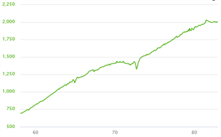
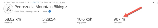
I have notice total ascent on a ride is wrong on my Edge 1000. 

I did exact same route with a friend and total ascent was different, approx 900 m for me, and more than 1100 for him.

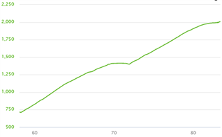
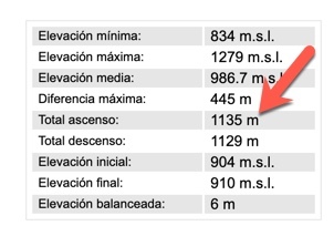
I import the GPX to a page to calculate and it give me the proper total ascent. ()

Garmin Info

Real Info

Any idea how to fix this?

thanks

  • Hi

    nobody had any idea? for me is a big error, more than 20% so not sure if barometer error can justify this.

    any idea?

  • The total ascent shown on the Edge 1000 is not identical to summing up point-to-point elevation gain in the file, it is obviously calculated somewhat differently, including more smoothing. I see the same in my data (sometimes more, sometimes less), so it is not unusual and no sign that your device may be faulty. Especially: there is no fix.

    After about 15 years of using barometer based altimeters (and often using 2 devices in parallel on the same ride, like an etrex and a sigma bike computer, or now an Edge 1000 and a Fenix 6) I found that I never got the same values from any 2 devices. Differences of 10...30% are common. The Edge 1000 is definitely on the low end of reported total ascent, but reports very similar values when I ride the same route again. My Fenix 6 reports considerably higher values (up to 30%), but seems to be very sensitive to wind (wind = pressure changes which translate in altitude change) - the difference is higher when it is very windy.

    But which value is correct? Which device gives the most accurate value? Is the value calculated from the file correct? I haven't found a way to answer this question. Also in your case: how do you know that the bigger value is correct? On a 5 h trip there can be many pressure changes due to wind and local weather which may add up to many meters of ascent (if you use 1 sec recording interval, you have about 20000 data points!). The internal calculation of the Edge obviously tries to avoid adding up many small ups and downs, but maybe does a bit too much.

    In conclusion: my experience is that the Edge 1000 gives a stable, but compared to other devices low value for total ascent. I trust it more than my Fenix 6.

    You can take the Edge value as a lower limit for total ascent. If you like bigger numbers, take the values from the file - who can say what is more "correct"?

  • Hi

    thanks for the explanation. I know Edge 100o ascent is wrong as I did this ride with more people with different devices (other Garmins...) and all other ascent was around 1100 meters. Same as me if I calculate based on GPX and not on barometer...

    I understand we can not have exact the same numbers, but for me more than 20% is too much deviation. 

    I also understand that you consistently confirm that Edge 1000 is giving lower ascent, so, not sure if Garmin should take a look to the software and see if this can be improved.

    Meantime, there is a way to use map altitude instead of barometric?

    I probably miss something, but I feel with current technology and online maps using map instead of barometer will give you more accurate values, so not sure why we need to continue using barometer, or at least we should be able to choose...

    Meantime i will try to increase points and see if it mitigates a bit.

    thansk in advance..

  • Hi,

    regarding map based elevation using a digital elevation model (DEM): there exist several DEM with different accuracy and resolution, especially the freely available DEM may be quite limited, so I doubt they would increase accuracy for total ascent.

    You can actually try this in Garmin Connect (website, not mobile): There is a feature called elevation correction (i.e. use DEM), see support article: https://support.garmin.com/en-US/en/?faq=R4I5hFFcUk8gJPC4zi0Xv6

    But even if the DEM would be perfect, there are other reasons why this method may not give accurate results. Here is an example (riding up  Simplon pass in switzerland), left with elevation correction enabled in Garmin connect, right the barometer based elevation data from the device (etrex 30). Total ascent (including more than the part shown) is 1963 m for DEM data and 1497 m for barometer data.

    The left graph shows lots of wiggles and even spikes which were definitely not in the road - the right graph is much closer to reality. The reasons are:

    • GPS accuracy: when the recorded track is not on the road, the elevation is taken from the wrong place - in steep terrain this can be several meters up or down. And in mountainous areas GPS reception is often not good due to limited view of the sky. (Actually low DEM resolution and accuracy can cause the same effect.)
    • The DEM does not include bridges or tunnels. The sharp 120 m dip in the left graph after the flat section in the centre is caused by this:

    As you see: there is no simple answer to the question "How do I get correct ascent data?".

  • Hi

    Thanks again, what you say make totally sense. But I still wonder why other GPS devices (both of them garmin) are more aligned with reality. 

    I understand we can not get 100% accuracy and same values for different devices, but the difference from Edge 1000 and other is SO big, so for me there is something wired on the device.

    Thanks