Fenix 6 Series - 20.41 Public Beta

Hello Fenix 6 customers,

Our next beta version for the Fenix 6 series is now available! 

Please ensure that you are downloading the correct beta software for your specific device.

Instructions for installation are available below the change log on each of the above pages.

20.41 Change Log Notes:

  • Updated the software update process to allow the user to defer the installation. This replaces the automatic install during the user's sleep window.
  • Improved altitude calibration.
  • Fixed intermittent issue where device would freeze when starting a round of golf.
  • Fixed issue that would cause device shutdown when editing HIIT data fields.
  • Fixed issue where the device would create empty golf scorecards.
  • Fixed issue where the activity timer could be enabled on the Map-App. (Pro models)

Current beta peripheral software version numbers below. New versions are indicated in red.

GPS: 5.30
Sensor Hub: 11.01
ANT/BLE/BT (Pro models): 6.11
ANT/BLE (non-Pro models): 3.00
Wi-Fi (Pro models only): 2.60

Please note, the beta updates released on these forums are not compatible for APAC region devices.

Please send all bug reports to [email protected], and indicate which model of the Fenix 6 Series you have in the subject line.


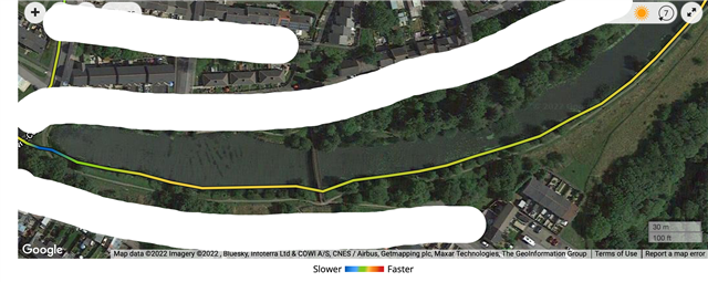
  • This is the bit - so yeah its believable it would be flat - there are two paths, the plotted line is correct where it is, the path below is down a banking on the road below the lake. I don't run here very often so did a quick scout through my activities and it's believable - but I couldn't say for 100% there's not a pause here - but, given the path is flat anyway I'll call this one as 'unverifiable' as a altimeter pause Slight smile

    I'll see what happens tomorrow as it'll be an up and downer through the valley in which I live and as it will be dark the route I use I know well and can spot anything out of the ordinary - although I do suspect there may be some altitude smoothening. I notice I get smoother altitude tracks than others people have posted here (but looking back I always have, even with other watches) so it's hard to tell whether there's possibly underlying hardware problems others have had here. But there may be more stronger smoothing here


    It's from ~14:30 - 17:30 in the data and that is where I enter the path on the left and then leave it on the right, 3 minutes to go about 500m, which does agree with the rough speed I was doing there (early on in, so was still reasonably motoring :) )

    EDIT: oops no looking on the map, no there's a bit of a shift downwards for the first bit but as I leave the lake area it goes back (GPS+Galileo, 1 sec) but its still a flat path. So the altitude looks correct here, may be shifted over at this stage. Not seeing much else shift elsewhere but it's a bit harder to see on the other bits as there's only a few K on clearly marked routes on the map as after I leave this lake area I head up sheep paths!

  • Although I think I've possibly spotted a bug in GC Web doing this 

    If I have elevation by distance and try to trace the bit on the elevation graph the pop up doesnt show the correct altitude, but ut does if I view by time

  • To add a bit of context, I started the walk at around 19m of altitude and reached 1-2m (by the sea). Not a single stair, just gentle incline as always for a city by the sea.

    Altimeter is definitely broken in this version.

  • I switched from sensor mode "auto" to "barometer only". Now, the altitude is stuck at 11 meters, no matter what I do. I went down the stairs from my apartment and then down another flight down into the basement and it never registered anything. Is that normal?

    I'm guessing that's what happens during my activities. The sensor mode auto-switches to barometer mode and the whole thing takes a nap.


    That's one way to stop altitude drift, I guess Stuck out tongue winking eye...

  • I switched from sensor mode "auto" to "barometer only". Now, the altitude is stuck at 11 meters, no matter what I do. I went down the stairs from my apartment and then down another flight down into the basement and it never registered anything. Is that normal?

    That's the intended behavior of "barometer only". It means that each pressure variation is interpreted as real variation in atmospheric pressure at constant elevation.

  • Thank you for clearing that up. 

  • Why are Garmin not testing this internally as this beta program isn't working if it's going out with huge bugs like this? 

    A few un-demanding users saying 'it works fine' in these beta threads clearly is NOT sufficient testing to justify rolling this out. It's completely broken - even in my house which is around 180 feet, I am seeing regular drifts down to 130 feet during the day. And with activities it's worse.

    Garmin - you have tried to 'fix' something that was never broken - what is the motivation behind this bonkers change?

    It's incredible, isn't it? Apparently, Garmin have pushed out this algorithm to all their watches, Fenix, Instinct and Epix included. And 'un-demanding' users nails it completely. It's so annoying. People who have no idea what they are talking about fanboyishly defend Garmin. I have no idea why they changed anything. I was speculating that it's about a patent infringement, but I don't really think so.

    forums.garmin.com/.../the-terrible-altimeter-calibration-change-from-15-00-16-00-to-16-50-once-again-shows-everything-that-is-wrong-with-garmin-updated-same-problem-on-fenix-and-epix-2

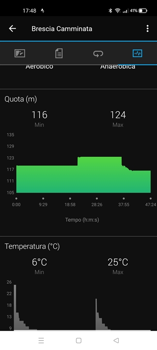
  • During my last walk with 20.41I experienced the altitude bug as well...

  • Yeah I think I'm seeing it. But I'm wondering if it's an over enthusiastic smoothing routine than a pause, per se.  I'm seeing two flat spots in today's 21k but I'll have to wait till I get home and look at it on the laptop to be sure as they're quite short.. I'll look at it with the map and see if it is what it looks like