Enduro 3 gps accuracy

Hi everyone! One of the most annoying thing in Garmin wearables was inability to delete wrong GPS points in the middle of the trek, when it's suddenly jumps around canyon walls, for example, and due to elevation change adds a lot of distance to your trek. Recently I did my first little hike with new Enduro 3 and met exactly the same problem not even in canyon but during little swim. 


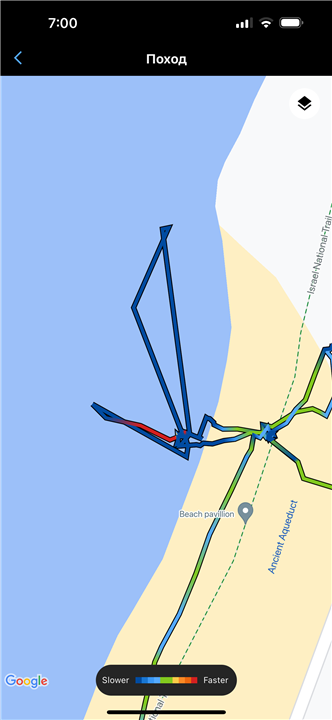
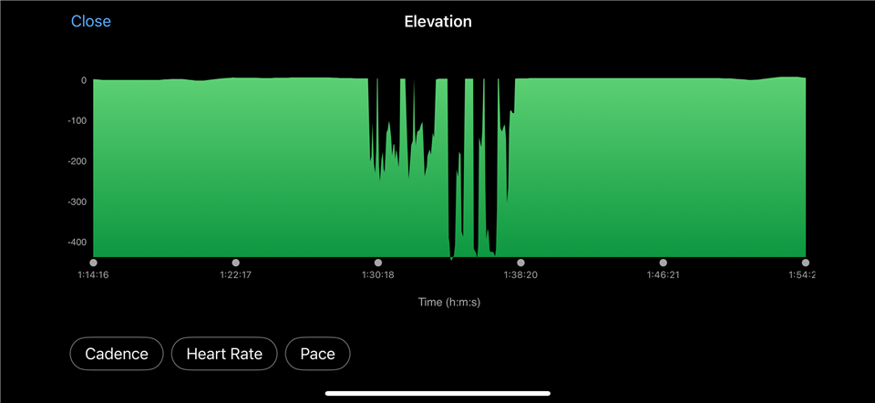
as you can see, Enduro 3 decided that I somehow jumps around the sea going up to -400 meters deep and back. 
All together it resulted 7 km track distance almost doubled!! 

there is still no possibility to delete wrong points in the middle of the track in Garmin connect, which is very disappointing. GPS accuracy was the primary reason I have upgraded my delta to Enduro 3 and it's a pity this problem was not addressed anyhow. 

my GPS option is set to Auto Select and touch screen locked. 

would appreciate any comments, which proves me wrong! 

  • The elevation comes from the barometric pressure sensor, not from GPS. When you submerge the watch, it not ony loses the GPS signal, but the pressure sensor is exposed to a much higher pressure, and translates it to a dip in altitude. It looks like you used the Hike activity, I recommend using the Open Water Swim activity when swimming. It will avoid this kind of problems.

    And if you want to have a decent GPS track during your swims, you either have to swim front crawl, or another style where the arm wearing the watch comes frequently above the surface, or you have to keep the watch under the swim cap, or on a float. GPS does not work under the surface. Just a few millimeters of water are enough to damp the signal practically completely.

  • but during little swim.

    What activity had you selected? GPS settings are activity specific so you should always use the appropriate activity. 

  • Indeed I was using hike activity, and indeed I expected Garmin with their new advertised SatIQ technology to handle short submerge in water as this was equal to river crossing. I hope you do not expect anyone to stop hike activity and change to Open Water Swim when crossing rivers? 
    instead Garmin was supposed to understand I can not jump dozens of meters in a second during hike activity as well as can not jump 400 meters in altitude. They advertised they did, but actually they did not. 

  • I expected Garmin with their new advertised SatIQ technology to handle short submerge in water

    No way. Gigahertz frequencies do not spread underwater, regardless whether it is a short dip or a long one, and regardless how good your technology is. You can't fool the physics. You could perhaps get some signal with a high powered handheld hi-tech portable device, a few centimeters below the surface, but even that's not sure.

    I hope you do not expect anyone to stop hike activity and change to Open Water Swim when crossing rivers? 

    Personally, I do not care how you record your activities, but if you want accurate results, then all I can advise is to use the function "Change Sport", and quickly changing from hike to swim, if you are going to swim, and then again Change Sport back to the Hiking, when back on the land.

  • Just pausing the activity if there is no interest in recording the swim would also be an easy solution.

  • Sure. That means that watches got weak GPS signal, likely when being above the water level and just recorded them into track regardless of the absurdity of this data. So claims that Fenix 8 and Enduro 3  "Added new online processing of troubled GPS tracks, using internal watch sensor data to correct them" is not true. It doesn't do any post processing. 

  • The elevation errors you see have no relation to GPS at all. They are caused by the water in the barometric altimeter porthole. As long as you avoid that, the watch indeed records the distance all right even with a weak or completely lacking GPS signal.

  • when You hike and submerse watch underwater,  pressure jumps because every 10 meters of water make same pressure as whole atmosphere. submerging watch on centimeters gives hunderts meters of altitude change.

    You can try add DEM data post-upload on garmin connect -> activigies -> activity -> menu under watch picture.

  • Tried it already. Does not change anything 

  • Tried it already.

    Tried what? Are you telling you see big elevation dips to negative hundreds of meters even when the watch is kept dry? Or do you see elevation changes while using the OW Swim activity?