Measuring Distance Traveled in a Dive

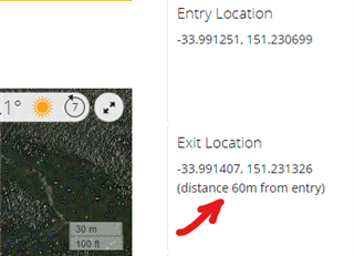
How do you get the distance traveled during a dive? 

I have the starting and ending GPS coordinates in the logbook, why does it not show the distance traveled?

Any easy way, besides using a GPS coordinates travel calculator?

It would be very nice if it was included in the log app, it's useful information and easy calculations, why is it not included?

  • The Descent will give you the entry point and exit point GPS coordinates. Most dives are rarely a straight line, so just using these two coordinates will not give you the distance traveled during most dives. With enough sensors and accelerometers I suppose you could estimate the distance traveled, though the Descent does not provide this. In fact there may only be one or two dive computers that might be able to provide this, and even they do not provide this number. 

  • With enough sensors and accelerometers I suppose you could estimate the distance traveled

    Not easily. The accelerometer detects acceleration, not the velocity. OK, in ideal conditions in vacuum and without any friction, having the watch attached to your body and not the writst, and knowing your exact inertial mass (including the equipment), it is theoretically possible to calculate the velocity from the acceleration, but in real conditions with many unknown factors like the mass, friction, currents, etc., it is practically imposible. At best, you get very inaccurate and misleading estimate values.

  • Well I did not say it was possible, I said with enough sensors and accelerometers I suppose you could estimate. This is going to be a challenge to make work in most real world situations. I know it has been tried, well sort of tried, but not sure how effective it actually is. Two high end tech computers say they can nav you back to your starting point, though not sure if they track distance traveled. 

  • Two high end tech computers say they can nav you back to your starting point, though not sure if they track distance traveled. 

    Don't they, rather than sensors, use acoustic positioning systems, or something similar, instead? Can you name the models? I'd be interested in reading up their claims.

  • I'm in Cozumel. so yes most dives are a pretty straight line... It sure would be nice to have a linear distance displayed... I mean, if the Descent gives you starting and ending coordinates, why not make something out of it and display linear distance, from point a to point b, even if it's not a straight dive, it would be nice to see linear distance traveled, you could even estimate speed of current!

  • it would be nice to see linear distance traveled,

    OK, here you go. You can turn it on with the local overrides v1.13, now (using the Haversine formula for calculating the distance between the two points, and locally injecting the Javascript code and the result into the page). See an example below. Currently it only shows the distance in meters, but I will add imperial units too. Just have no idea what you'd prefere - inches, feet, yards, miles, nautical miles?

  • PS: I am not sure whether it happens that there are multiple positions at the entry and exit points (i.e. at interrupted dives). If you have any such dive with multiple values, and see the distance is wrong, please make the activity public, and post the link to it - I will check out how to fix it.

  • And gyroscope?

    A gyroscope can detect a change in the orientation or in the direction, but it cannot detect the speed you are moving with, or the current that carries you away. 

  • Really? How do inertial guidance systems work then?