This discussion has been locked.
You can no longer post new replies to this discussion. If you have a question you can start a new discussion

How to change the colour of 'navigation/course follow line' with your own map theme!

As I've posted in this thread, by , the navigation line in my watch changed sometime in the middle of Sept. to a much thinner one that I've trouble seeing with most of my maps: https://forums.garmin.com/outdoor-recreation/outdoor-recreation/f/fenix-6-series/194034/how-to-change-the-colour-of-the-navigation-line

Contacted support, but they didn't have an answer.

I started to test what possibilities with the map theme files and found out that this style field="MPM_ACTV_CRS_CLR" is used for the navigation line.
If you create different map theme files with different colours, you can even change the colour while running depending on the map background.

Create a text file and save with extension 'kmtf' to the map theme folder on watch.

This text give you a dark green line with dark green borders.

<?xml version="1.0" encoding="UTF-8"?>
<garmin_map_theme>
	<metadata>
		<title>DarkGreen</title>
		<description>DarkGreen</description>
	</metadata>
	<stylelist>
		<style field="MPM_ACTV_CRS_CLR">
			<color>
				<primary day="#ff006400" night="#ff006400"/>
				<secondary day="#ff006400" night="#ff006400"/>
			</color>
		</style>
	</stylelist>
</garmin_map_theme>

Great color code page: http://www.farb-tabelle.de/en/table-of-color.htm

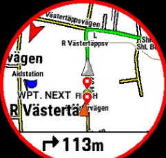
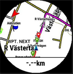
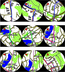
Some examples: Blue, green, magenta and the last-right one are red with blue borders.
The two bottom-left is the thin original that shows up if no theme is used.
  • There is a scale parameter in themes file that I found was used in Garmin car gpses. When testing that in the beginning with fenix I didn't get it to work.

    Maybe someone else would like to try it out now.

    <stylelist>
    <style field="MPM_ACTV_CRS_CLR" scale = "2" border = "1.00">

    You can change the width of map signs by updating TYP-file in map file. See this thread where I have example and how-to: forums.garmin.com/.../here-is-an-illustration-of-turn-by-turn-navigation-being-misleading-and-map-rendering-not-helping

  • Thanks! Looks promising!

  • Thanks for the link.. : -) 

  • You can try my TYP file first, just to test another TYP and then you can go on modifying it for your own needs.

    I really need to update mine, so I write it down as I do it myself.

    (This is for a windows computer. No idea what tools available for Mac.)

    1. Download an OSM map of your own choice. I've been using this site lately. Update maps really often. https://alternativaslibres.org/en/downloads.php Download your country map File for GPS/topographic. 
    2. Change filename to something describing for you and if you want a special name to pop up on the watch, use GMapTool  to edit "Mapset name".
    3. Download my typ file from here and save it to the same folder as your img file.
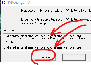
    4. Download and start this small and really easy tool, TYPchanger
    5. Drag your img AND my typ file into the TYPchanger app. Hit 'Change' button. Wait for Done.
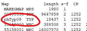
    6. With GMapTool you can double-check that the typ is changed. Not necessary though. 
    7. Drag your new img file into the Garmin folder of your watch.
    8. Disable Garmin maps and enable your new map in every activity/app on the watch you would like to use it in.

    If you would like to edit the typ file, I use TYPviewer app.

    All these tools are really old, but they do work:)

    (If you use another site to download OSM, It's important that the file you download contain a TYP-file from the beginning. TYPchanger does not work otherwise.
    You can check the downloaded file with GMapTool. Drag img file into it and tap 'Info' button. You should see a TYP file in the file list like you can see above in point 6)

    ::::::::::::::::::::::::::::::::::::::::

    Thanks for this excellent map type file.... I paired it with a Transparent trails map from Frikart.... So I can now use your type file in the transparent layer on any of my maps without actually changing them..so I can toggle the new layer on or off... This is brilliant.... The trails are soooo much easier to see!... Looks better on any map!!.. it really suits the small screen.... Even stands out over Birdseye where they were difficult to see before,(paired other maps) making the satalite imagery more easier to read with your type file, when compared to standard trail maps!.... This is staying on my watch..... Thanks for all your shared work!... Made my day!! 

  • Maybe put the info oín this thread also for Map Theme doc:

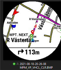
    There is a way to control the appearance of the VP arrow. It can be customized via custom map themes. You can see how it changes between built-in map themes.

    Standard:

    Orange

    Black borders VP_VHCL_BRDR

    Almost invisible/transparent (just some white overlay left), maybe that can be fixed to totally invisible.

    Red VP_VHCL

    Style Fields for the black border and the other ones transparent.

    <style field="MPM_VP_VHCL_CLR"><color>
    <primary day="#00ffffff" night="#00ffffff"/>
    <secondary day="#00ffffff" night="#00ffffff"/></color></style>
    <style field="MPM_VP_VHCL_BRDR_CLR"><color>
    <primary day="#ff000000" night="#ff000000"/>
    <secondary day="#ff000000" night="#ff000000"/></color></style>
    <style field="MPM_VP_VHCL_LEFT_CLR"><color>
    <primary day="#00ffffff" night="#00ffffff"/>
    <secondary day="#00ffffff" night="#00ffffff"/></color></style>
    <style field="MPM_VP_VHCL_RGHT_CLR"><color>
    <primary day="#00ffffff" night="#00ffffff"/>
    <secondary day="#00ffffff" night="#00ffffff"/></color></style>
    <style field="MPM_VP_VHCL_BACK_CLR"><color>
    <primary day="#00ffffff" night="#00ffffff"/>
    <secondary day="#00ffffff" night="#00ffffff"/></color></style>

    I cant find a way to get the inner borders to be transparent!

    If you find this interesting go to this folder

    https://1drv.ms/f/s!ArcZbYTRM95XgpRe8m2uYlWnQwzByw

    and download: VPblackBrdr.kmtf, VPorange.kmtf, VPtransp.kmtf

    Copy them to the Garmin/Mapthemes folder on watch.

    Go to your activity setting and change the map theme.

  • Thanks Phoglund for the new arrow files, I've downloaded them, (I've still got your navigation line map themes installed as well) and are all now working perfectly on my 6x Sapphire...

    Thanks for taking the time to share with us... 

    All the best Thumbsup 

  • Anyone knows how to change the map style / theme on Forerunner 945? 

    What's the directory path of the map themes on Fenix 6 pro?

  • I would expect the 945 to be the same as the fenix6.

    Look for a folder named 'map theme' below the Garmin folder.

  • I also expected that... I could upload additional maps other than Garmin's. But the Map Theme option in Map settings, as well as the 'map theme' folder is missing. It's also missing in the manual. (All other map settings are equal)

    Map settings 945
    https://www8.garmin.com/manuals/webhelp/forerunner945/EN-US/GUID-60C3B7A5-51ED-4E4D-A2DC-8578234EF279.html
     

    Map settings fenix 6
    https://www8.garmin.com/manuals/webhelp/fenix66s6xpro/EN-US/GUID-60C3B7A5-51ED-4E4D-A2DC-8578234EF279.html 

    I really don't like this fat purple line and the arrow...Unamused

  • What fenix 6 version do you have?