Weather report via inReach for Mountaineers

Hi,

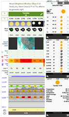
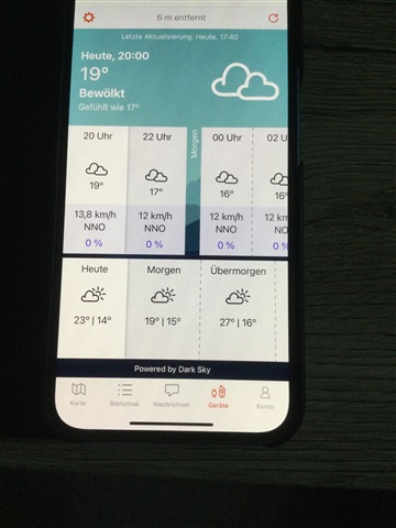
I used the weather report of in reach Mini and this report is useless for mountaineers.

The weather report bases on DarkSky and they have only some reference stations. The current altitude is not part of the forecast, wind direction or wind speed is completely wrong if you are

in height of 2000 - 3000 meters because the weather forecast station is normally the next city (normally in the valley).

Sorry Garmin. Its not really a professional device for longer outdoor trips in the mountains.

Best regards

Florian

  • I've used Mountain-Forecast.com occasionally.  I'll have to check out these other options.  Thanks for sharing.

    -- Pete

  • I didn't realize this, very disappointing! The feature WAS the icing on the cake for me. Unlike the user below, it IS a core feature listed in a prominent place on the website and marketing material! And yes other planning should be undertaken just as is mentioned below and the weather changes fast but surely its a perfect use-case for the device due to the 'fast and light' nature of users and the compact and light nature of this device. It would seem to be such an easy fix. Its a great device in many respects just let down by a few resolvable issues!

  • I found this discussion very interesting, so I used one of the sources other users listed as 'more reliable' and compared the results to the forecast my inReach device produced for a location 'in the mountains':

  • I believe the problem Florian raised four years ago still exists.  And I think it is worth considering.  Backcountry travel/living is not the only application for InReach devices, but it is one of the main reasons people use them.  If a user tests the InReach weather before he leaves home, he'll probably get an accurate forecast since he probably lives near a weather station.  He will not discover his mistake until it's too late.  The InReach forecast he gets from a location far from a weather station will probably be wrong and might be dangerously wrong.

    My solution to the problem in the United States is to ignore InReach weather.  Instead, I send an InReach message to a friend with Internet access.  The United States the Weather Service provides highly localized and detailed forecasts that take terrain, wind direction, etc. into account.  The forecasts are specific to each 2.5km x 2.5km (6.25km^2) location based on approximations from surrounding weather stations and then adjusted for that location's specific geography and forecast winds.  The hour-by-hour forecasts for seven days out are updated every three hours and include a great deal of information, even information incidental to weather like the minimum elevation of snowpack.  You can access the forecasts by browsing to IDSS Forecast Points (weather.gov).  From there, enter the coordinates of any location in the United States in decimal degrees, e.g. 43.56789, -90.012345, into the search window.  Alternatively, you can use a scalable map to click on an precise location and get the forecast for that 6.25km^2 area.  The clickable map is useful if I need a forecast for somewhere other than my location.  But since my messages will have my coordinates in them, the search window is usually best for my location.

    If people who see this post know of other countries that have similar localized forecast services, please post the information here.

  • Meteoblue have excellent mountain forecasts, localized to a small area and with altitude 

  • If anyone would like Wx directly from U.S. National Weather Service, check out this page:  wx2inreach.weebly.com

    The returned text messages are very configurable for your needs.  I often use it instead of the InReach option.  Sometimes I compare the two forecasts, and they are usually reasonably close for the remote places I hike and camp in the American West.  (I don't know if InReach still uses a version of DarkSky, don't currently have my device to verify.)

    Looks like they now offer non-U.S. forecasts via a service called VisualCrossing.com

  • I've done some more comparisons at different locations in the United States in August 2023.

    The Dark Sky weather provided by the Garmin app called "InReach Weather" on the 67i and the Weebly text message weather both appear to be using the localized point forecasts provided by the National Weather Service. 

    The Garmin/Dark Sky weather forecast inaccuracies may be limited to probability of precipitation.  Information like temperature and windspeed/direction appear to match the National Weather Service point forecasts.  So this may be an improvement from the four-year-old post that began this thread.  That post complained that forecasts were from far away weather stations with different elevations.  The Garmin/Dark Sky forecasts I checked were approximately the same as the Weather Service point forecasts which take terrain and elevation into account.

    However, the Garmin/Dark Sky forecasts are seriously askew on precipitation.  In all my checks, they reported the probability as zero unless it was greater than or equal to 50 percent.  Where the Weather Service predicted a probability of, say, 20 percent, the Garmin/Dark Sky forecast always showed zero percent probability for the same time/location.  As I said in my first post, the Garmin/Dark Sky precipitation probabilities are sometimes logically implausible in that they will show a substantial probability of precipitation for a 24-hour period while each of the 12 two-hour periods has a zero percent probability of precipitation. It's hard to imagine how errors like that escaped beta testing.

    Unlike the Garmin/Dark Sky forecasts, the Weebly forecasts do not conflict with the National Weather Service point forecasts on precipitation.  However, because they are text based, they are less convenient.  To check a location other than your current location you must type in the coordinates.  You cannot use a waypoint or map location.  And reading the Weebly reports requires some deductive reasoning, since the 160-character message limit requires use of abbreviations.  Also, the message size limit means the Weebly forecasts provide slightly less detailed windspeed/direction.

  • Hello we no longer use Dark Sky for weather as things have been updated. Frequently Asked Questions on Weather for inReach

    Where Does the Weather Data Come From?

    • Land forecasts are powered by Meteoblue, a leading provider of weather data around the globe. Their site provides weather location review.
    • Marine forecasts are based on OCENS premium marine weather data which provide wave and wind levels to 1/100th of a degree lat or lon. Atlantic data sources includes; WW3 Multi-Global, WW3 Navy, NDFD, GFS Global Wave as well as HRRR and RAP for wind in some areas. 
  • My Explore app (iOS 3.8.1) is still showing dark sky as provider:

  • We are looking into why it still shows Dark Sky. However it is coming from Meteoblue.