Mapshare questions

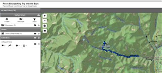
Hello all, setting up a mapshare for my wife to follow along from home for a short backpacking trip that i'm going to do with my boys this weekend. 

We're heading up to an alpine lake here in New Mexico and it will be the first time the boys have carried packs. I'd like to have mapshare show 2 things to my wife 

  1. our planned route 
  2. our actual track in near real time

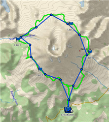
So first challenge. The course we are following is on my Fenix. My steps so far 

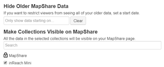
  1. Create a new collection on Explore called "inReach Mini" 
  2. Add the course that i'm going to follow into that collection 
  3. Add the inReach Mini collection to the mapshare filters 

The above gets me the course showing on the mapshare page 

So my questions 

  1. Is this the right way to go about doing this? 
  2. Will the live track points show as a different color or be distinguishable from the course? 

Thanks!

  • Location requests are $0.10 US on the Safety plan. Free otherwise.

  • If you were logging as well as sending, details between the sent points will "fill in" when you sync - either via the Earthmate app or via a wired sync. The level of detail will depend on the logging interval. If you did not log, the straight lines connecting sent points is all you're going to get.

  • I think I've finally got this thing mostly figured out.  Used it for a 50k trail run 100% out of cell range this past weekend and it worked perfectly. Added the course by importing into the inReach web page and made it visible on MapShare.  Had my mini sending current position every 30 minutes.  It was located at the top of my hydration pack.  Was able to send a preset message at the start/end without issue.  Even received a message from wife.

    The green was the pre-uploaded course.  Blue was the "Sent Point" track.  I have logging turned off since I get better detail from my watch.

    Thanks for all the help getting up to speed twolpert.